We have now undertaken two seasons of excavation at the site in 2014-2015. Directed by Ms Caitríona Moore and jointly funded by the Royal Irish Academy, Meath Co. Council and the OPW we have demonstrated that the largest enclosure is likely to be late Bronze Age in date with a possible closing date in the middle Iron Age. The southern enclosure was most likely constructed at the end of the Iron Age/beginning of the Early Medieval period, sometime in the 5th Century AD, with at least the outer circuits of Tlachtga constructed within one or two generations of this. The central area of the site is yet to be fully explored but trial excavations in 2014 identified in situ burned timbers of Anglo-Norman date, suggesting a possible later stronghold was constructed here. Post-excavation is continuing and funding is currently being sought for a third season of excavation in 2016.
The Hill of Ward Project
Principal Investigator
Dr Steve Davis, UCD School of Archaeology
The Hill of Ward, Co. Meath is (opens in a new window)located 2km to the east of the medieval town of Athboy, and comprises a gently rising outcrop of ‘Calp’ limestone and shale with a maximum OD of c. 140m. The hill is topped by a 150m quadrivallate earthen enclosure known by the Irish name of Tlachtga (occasionally Tlachta or Tlachtgha), usually translated as ‘earth spear’. In the ancient kingdom of Mide, Tlachtga was considered an important assembly place alongside Tara (Temhair/Temair), Teiltun and Uisneach. These four ‘corners’ are recorded as having been the location of fortresses constructed by high king Tuathal Techmar (who is described in Fragmentary Annals 116 as ‘Tuathal of Tlachtga’) at the foundation of Mide in the early decades of the first millennium AD.
The ‘Three Finds of Emain’, Bres, Nár and Lothár, sons of High King Eochaid Feidlech and triplet brothers of Queen Medb of Connacht are said to have dwelt at Tlachtga in the first century AD. Somewhat later, Geoffrey Keating in his ‘History of Ireland’ records Tlachtga as the centre of Irish Samhain traditions (equivalent to the modern festival of Halloween), noting that on the hill ‘the priests, augurs and druids of Ireland [would] assemble upon the eve of All Saints, in order to consume the sacrifices that were offered to their pagan gods’ (Keating 1809). This has led to Tlachtga being labelled as ‘the birthplace of Halloween’.
Funded By:
This project has been supported by Heritage Council, Office of Public Works (OPW), Royal Irish Academy (RIA), Meath County Council
Initial geophysical survey (with Dr Chris Carey, University of Brighton), funded by the Heritage Council in 2011 revealed that the present enclosure is part of a complex of three partially overlapping enclosures on the hilltop: it overlies a much larger, 195m diameter closely-spaced trivallate enclosure and a smaller subcircular enclosure to the south, c. 40m in diameter. Subsequent geophysical survey (with Dr Carey, Elizabeth Richley, University of Southampton and Susan Curran, UCD) now extends to approximately 30ha and has highlighted significant landscape-scale complexity, with elements of prehistoric, early medieval and Anglo-Norman settlement in evidence.
A small area of LiDAR coverage centred on the Hill was obtained from the OSI in order to better contextualise the archaeology of the site. Despite the presence of an important 'royal' site at the hill's summit, the known archaeology of the area immediately surrounding the hill is sparse. Beyond the royal site itself (ME030-001) only two sites have been recorded; a church (Temple Cuimhneas - ME030-002) and a well (ME030-030). Given the often archaeologically complex remains at such royal sites (e.g. at Tara or Rathcroghan) it was anticipated that analysis of LiDAR might bring to light previously unidentified low-profile archaeological features and so enhance our archaeological understanding of landscape in the vicinity of the hill itself, as well as providing a starting point for ground-based investigations through geophysical survey.
Previously unidentified archaeological features
A range of previously undentified features of potential archaeological interest have been identified from the LiDAR coverage. These include:
The outer banks
A pair of low-profile curvilinear banks, which run between the NW section of the Ward ridge and the northern spur. These are approximately 60 m apart and extend in a shallow arc, the outermost extending for c. 200 m (Fig. 1). They occupy the shallowest approach to the summit of the hill.
Fig. 1. Outer parallel earthworks. Note other straight field boundary features to the east and adjacent to Tlachtga itself.
The embanked enclosure
To the east of the remains of Temple Cuimhneas lies a large, circular embanked enclosure in excess of 150 m in diameter, bisected by and E-W field boundary. The majority of the surviving banks are extremely low profile, in the region if 15 cm vertical expression. There appears to be a small gap in the bank a few degrees east of north, definine an entrance while to the south the enclosure is interrupted by a small mound. A cross-section through the site reveals it to comprise a shallow dish-like form, reminiscent of similar enclosures at Brú na Bóinne (Fig. 2).
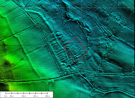 Fig. 2. Embanked enclosure to the east of Tlachtga. Cross-section from W-E showing typical 'saucer-shaped' form. Mound in SE quadrant and possible entrance to NNE indicated.
The possible settlement
Two fields to the east of the hill itself is located a 'D'-shaped field. In 6" OSI mapping this is conspicuous as the meeting place of ten field boundaries which radiate from some now obscured focal point. The LiDAR imagery shows what appear to be land divisions running along the western side of this field. These are upstanding to a height of 20-30 cm and measure c. 65 m by up to 25 m (Fig. 3).
In the SE corner of the field lies a larger rectangular enclosure of 100 x 120 m, subdivided into several distinct compartments. To the NW lies a roughly circular feature while at the southeastern corner lies a larger rectangular foundation, measuring some 28 x 14 m. These features are reminiscent of a bawn-type enclosure and require further archaeological investigation.
 Fig. 3. Possible medieval settlement to the east of the Hill of Ward. Note land divisions on western edge, and large, rectangular enclosure with circular foundation in NW corner and rectangular foundation at SW corner.
The mound in the esker
To the NE of the hill is located a small esker which in places shows signs of quarrying. A small, circular feature was noted through Google Earth, apparently cut into this esker and incorporating it in part. This comprises a small mound measuring some 35 m in diameter and 1.5 m in height, surrounded by a shallow ditch and bank arrangement. In form this resembles a small bowl barrow, constructed to make use of the underlying topography (Fig. 4).
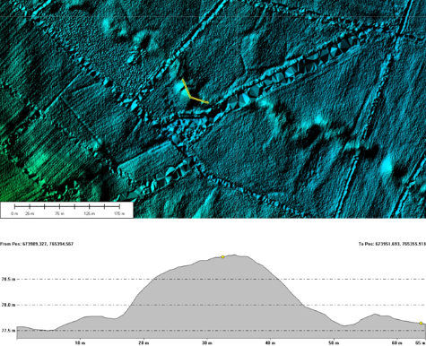 Fig. 4. Embanked mound built within the line of an esker. Section (below) runs from N to SE, incorporating best preserved bank sections.
Circular ditched enclosures
A number of circular, ditched enclosures are evident, concentrated in the eastern side of the current LiDAR extent. The largest and clearest of these lies to the NE and is bisected by a field boundary running ENE-WSW. It measures c. 70 m in diameter and domes slightly towards the centre (Fig. 5). A smaller example can be seen in the field to the south of the possible embanked enclosure (Fig. 8).
Fig. 5. Ditched enclosure to NE of the Hill of Ward. Cross-section runs E-W parallel with field boundary.
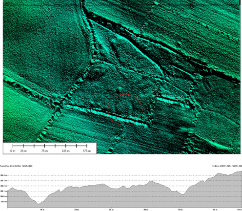 Fig. 6. Small ditched enclosure located ESE of the Hill of Ward with W-E cross-section.