Expanding Landscapes: a reappraisal of agricultural systems and landscape enclosure in medieval and early-modern Ireland, c. 1100 – 1800 AD
PhD Candidate: Michael Corcoran
Supervisor: Professor Tadhg O'Keeffe, Dr. Steve Davis & Stuart Green, Teagasc Spatial Analysis Unit
Funded By: (opens in a new window)Teagasc Walsh Fellowships Programme
Abstract
In what was more or less a critique of contemporary research into Irish medieval field systems, Butlin (1978) called for the ‘detailed regional and local investigations which are badly needed for medieval Ireland…’ Thirty-five years later, where do we stand? Mainstream research into the development of Irish agricultural systems, by and large, has not moved beyond the traditional narrative of a ‘native vs. Norman’ dichotomy wherein invading colonists stamped an ‘English midlands’ agricultural & tenurial structure onto a native Irish canvas of infield-outfield, largely pastoral landscapes. Implicit to this narrative is the idea that the division of Ireland into two agro-climatic zones – south and east vs. north and west – reflected corresponding divisions in cultural identities and behaviours across the Irish landscape. There are a number of issues with this narrative. First of all it lacks the necessary resolution required to explore local-scale agricultural decision-making and response to changing environments. However, more pressing is the basic lack of evidence throughout. For example, while the survival of medieval strip fields and fossilised plough headlands has long been recognised, remains of medieval ridge?and?furrow such as one finds in England have generally remained elusive (for a useful overview see O’Sullivan & Downey 2007). Moreover, there has been no systematic attempt to date what evidence we do possess for ploughing before the nineteenth century. Also, there has been no careful study of land?enclosure patterns in areas of former medieval manorial settlement, and therefore no basis on which to argue that arable became less common after 1300 as land was enclosed to facilitate a rise in pastoral farming. Finally, there has been no systematic study of arable patterns and their landscape manifestations in the late 1700s, despite the abundant historical sources.
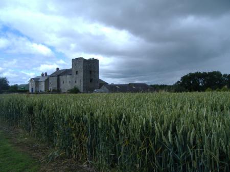 Figure 1. Athclare Castle, Co. Louth.
The aim of this research is to address some of these issues and to create a more accurate profile of changes in Irish agricultural practice, from the pre-Anglo-Norman late twelfth century to the period of expansion of grain production and export in the later eighteenth century (Bell & Watson 2008). The project will use a combination of landscape archaeological survey and study of historical documentary and cartographic sources, focusing on three study areas in the east, south and northwest of the country. The survey component will adopt a multi-layered approach, using data from such sources as aerial orthophotography and airborne laser scanning (ALS, also known as LiDAR; Figure 2) and site-specific mapping using GIS. Palynological analysis of soil samples will also be carried out; targeting locations such as waterlogged fosses of moated sites, plough headlands and raised wetland areas. The aim of this analysis will be to gather evidence of changing land-use and the creation of a contextual profile of climate change during the focus time period.
It is expected that this research will generate new data and offer some fresh perspectives on long-standing issues, some of which having been mentioned above, and shed new light on societal responses to what were often rapidly changing environments.
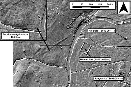 Figure 2. Composite hillshaded DTM of Monalumpera, Co. Tipperary (sun angle = 10°, azimuth 1 = 285°, azimuth 2 = 15°, Z exaggeration = 1, STD = 2). Note two phases of large-scale agricultural ridging. LiDAR data courtesy of the Office of Public Works (OPW)
Additional Information:
(opens in a new window)LiDAR in Archaeology
References:
Bell, Jonathan & Watson, Mervyn. 2008. A History of Irish Farming 1750 – 1950. Dublin, Four Courts Press.
Butlin, Robin A. 1978. Some observations on the field systems of medieval Ireland. Geographica Polonica 38, 31-36.
O’Sullivan, Muiris & Downey, Liam. 2007. Fieldscapes – Anglo-Norman Footprints. Archaeology Ireland 21, 4, 32-35.