Workpackage 2 -Remote sensing for detection and characterisation of forest cover changes
Team
- Dr Stuart Green (Task Leader, Teagasc)
- Guy Serbin (Teagasc)
- Dr Fiona Cawkwell (UCC)
- Ms Preethi Balaji (UCC)
- Dr Kevin Black (FERS)
Background
This work package intends to develop a multi-stage image-based product and NFI
Inventory system to address two key issues:
- Quality of deforestation data in Ireland;
- Improved spatial representation of forest areas for UNFCCC and Kyoto reporting.
The proposal intends to:
Expand on previous remote sensing projects using spatial un-mixing of optical data and fusion of microwave and optical sensor data, to detect forest area change
with a high level of confidence.
Uce microwave backscatter signature to derive biomass stock changes using existing NFI and research data based on regression analysis.
The work-package is broken into major sub-tasks concerning, optical sensing, radar sensing, biomass modelling and data fusion (see organisation diagram below).
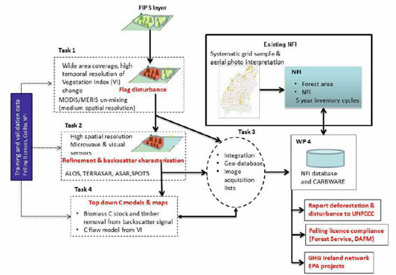
The multistage monitoring framework shows how information flows between tasks to WP4 and CARBWARE, and subsequently to augment NFI monitoring processes.
The Optical Task: Will produce estimates of forest disturbance at the forest scale, using medium resolution optical satellite data in conjunction
with land use data such as the forest information parcel system (FIPS). This will be achieved by using advanced signal processing techniques that allow
for the detection of events smaller than the pixel size (250-500m) of the satellite image. This task is lead by Teagasc.
The Radar Task: Will demonstrate how the nature of the disturbance can be characterised by high resolution optical and microwave satellites. It will
examine the use of regression models using microwave backscatter from forest parcels to determine biomass and timber volume changes directly. This task is lead by UCC.
Biomass Modelling Task: Will examine how vegetation index (VI) measurements from can be inverted to give direct estimates of GPP when ground-truthed against
flux tower data. This task is shared between partners.
There is also a data integration task to create an integrated geo-database to be delivered to WP4 for modification of the national reporting system
(CARBWARE) and to augment NFI monitoring processes with up to date information on changes in forest biomass and areas of disturbance. This task is lead by FERS Ltd.
Objectives
- Develop a national system for recording forest area change over time;
- Incorporation of new aerial deforestation and disturbance data;
- Investigate the use of low resolution remote sensing (RS) satellite imagery to monitor disturbance events in Forestry;
- Evaluate a range of radar sensors for characterisation and monitoring of forest disturbance in Ireland;
- Integrate high resolution optical and radar data to characterise the nature of disturbance events identified from the medium resolution data;
- Combine NFI and Coillte inventory data with image derived products to estimate carbon emissions/reductions and timber volume removal in felled areas;
- Use existing resources to spatially calibrate national carbon budgets and integrate with CARBWARE to deliver a multistage platform system for annual reporting of emission/reductions associated with disturbance.
Background information:
Disturbances in forest ecosystems arising from management activities are often poorly quantified in the short-term by normal inventory methodologies,
as well as by the inbuilt assumptions of reporting mechanisms. Thus, the following factors will be explored to assess the reliability of existing systems
and to develop new processes to improve the reporting capacity:
Identifying when and where events happen through analysis of imagery time series
Medium scale multi-spectral optical satellite instruments, such as MODIS and MERIS, have been designed to measure and monitor land-use and land-cover on a
daily basis with a resolution of between 250m and 1km.
The most important data product supplied by the medium resolution satellite images when looking at forest disturbance (harvesting, thinning, wind throw
and fire) is the Vegetation Index (VI). VIs have been linked to many plant properties such as, biomass, fractional cover, and leaf area index. For the
purposes of this discussion VI can be seen as a measure of "greenness", or in the case of forestry, canopy cover.
In the Irish context, the fact that the size of an average farm forest parcel is only slightly bigger than a MODIS/MERIS pixel (see image below) means that
events at the threshold of detection need to be included. However, well established techniques, such as pixel un-mixing, exist for looking at sub-pixel events.
Daily acquisition across the whole country means that individual forests can be tracked over years and the exact time and location of a deforestation
event can be determined reliably.
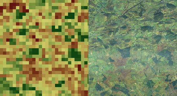
MODIS Vegetation Index Image (left) and parcelled nature representative of much of Irish forestry (right).
Using Space-borne RADAR images
Even with daily acquisition, frequent and extensive periods of cloud-cover limit the utility of optical sensors. Microwave sensing can penetrate cloud-cover
and haze, and also operate in the absence of sunlight, thereby greatly increasing the number of successful image acquisitions. Microwave imaging is a form of
active remote sensing, whereby an antenna onboard the satellite platform emits pulses of energy at centimetre wavelengths, which pass through the atmosphere.
The microwave beam "illuminates" an area on the ground, known as the footprint, with energy backscattered from features within this region. The scattered pulse
is detected by a sensor onboard the satellite, with the intensity of the returned signal representing a function of roughness, geometry and moisture content of the
reflected surface.Unlike many optical sensors, microwave instruments view the surface from a side angle, with the interaction between the energy pulse and the surface dependent on the incident angle of the microwave beam and the surface. Different incident angles are suitable for different applications, e.g. a larger angle increasing the contrast between a forested and clear-cut area.
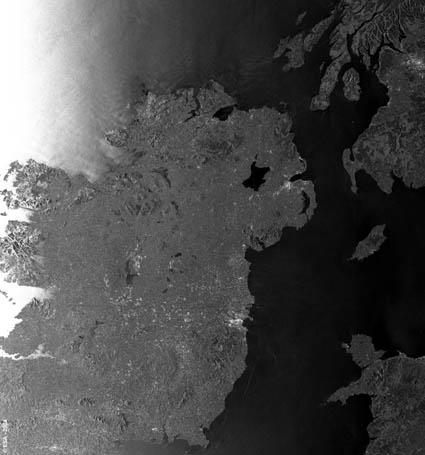
ENVISAT radar image of Ireland (courtesy of ESA).
For more information contact Dr Stuart Green.
BACK TO TOP