Wednesday, 28 January, 2026
Researcher: Dr Ungku Norani Sonet, Dr Ítalo Sousa de Sena, Dr Aura-Luciana Istrate, and Professor Francesco Pilla, UCD School of Architecture, Planning and Environmental Policy
Summary
This project developed an innovative methodology that enables children to meaningfully contribute to traffic safety and urban-design decisions using Minecraft. By exploring virtual replicas of their school neighbourhoods, children reflected on real traffic situations, answered spatially anchored questions, and re-designed streets in creative ways. The approach gave young people, who are rarely included in planning processes, a genuine voice in shaping safer and more inclusive streets.
Piloted in two primary schools in Utrecht, Netherlands, the workshops showed high levels of engagement, peer learning, and reflection. The findings are now informing citizen-engagement strategies within the Horizon Europe REALLOCATE project. A re-usable toolkit and facilitator guide support wider adoption across schools and cities in Europe, demonstrating how playful digital tools can inform policy, strengthen civic skills and support inclusive planning.
Research description
Designing a playful but rigorous approach
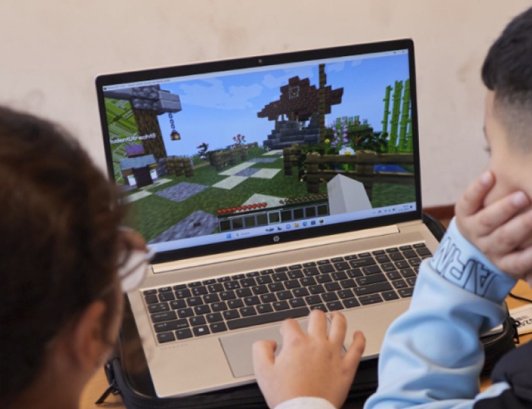
This initiative explored how Minecraft can be used to engage children in urban planning by capturing their views on traffic safety around their schools. The study took place in October 2024 as part of the Horizon Europe REALLOCATE project, which focuses on citizen participation in safe and inclusive urban mobility systems. Workshops were organised on site by REALLOCATE partners in Utrecht, with the engagement methodology designed and facilitated online by UCD researchers.
Key research insights
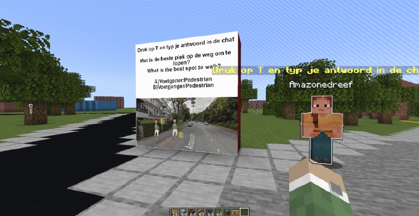
Children demonstrated high engagement and understanding when traffic safety questions were asked through the medium of Minecraft. Locating questions at real world intersections within the Minecraft map helped children relate responses directly to their everyday experiences. Public in-game chat encouraged peer learning, with children sometimes revising answers after seeing others’ responses. Iterative improvements between the two school workshops, including a smaller map area and clearer instructions, led to stronger engagement in the redesign phase.
Importantly, the game-based approach revealed not just what children know about traffic rules, but how they experience and move through their neighbourhoods, and what they perceive as unsafe.
How the research was carried out
The team developed a spatial questionnaire embedded within a Minecraft world that replicated real neighbourhoods using OpenStreetMap data. Workshops were co-designed with local facilitators and piloted in two primary schools. Children worked in pairs to navigate the virtual environment, respond to questions, and redesign streets using in game materials. Anonymised chat data, movement patterns, and design outputs were analysed alongside facilitator debriefs. This approach enabled the collection of rich spatial and qualitative data from children, a group rarely consulted in urban planning.
Research impact
Enabling children to shape safer streets
The project made a distinct contribution to inclusive urban planning by positioning children as active co-designers of traffic safety solutions. Across two workshops in Utrecht, 52 children aged 10–12 from diverse and multilingual backgrounds took part in co-designed sessions developed with local facilitators and teachers. Virtual replicas of school neighbourhoods allowed children to comment on specific locations and propose realistic changes grounded in their everyday experience.
Between 81 and 100 per cent of participants answered traffic safety questions correctly, showing strong engagement and comprehension. Shared gameplay and public chat supported peer learning, with some children revising their responses after seeing others’ ideas. Iterative improvements between workshops, informed by feedback from facilitators and participants, resulted in greater confidence and creativity in the street redesign phase, strengthening the quality and usability of the data generated for planners.
The kids were really reflecting on their streets in a way we’ve never seen before. This showed us a whole new method of engagement.
— Utrecht-based facilitator
Strengthening practice and participation
Children benefited directly by developing civic awareness and confidence in expressing views about their local environment in a format that was both playful and meaningful. Facilitators and educators gained practical capacity to deliver digital participatory workshops, supported by a facilitator manual developed from the research and shared across the REALLOCATE consortium.
Urban planners and engagement practitioners within REALLOCATE are using the findings to inform wider citizen-engagement strategies, particularly in relation to child-centred mobility planning. The structured methodology and re-usable tools offer a scalable way to include children’s voices in planning processes, helping to shape safer streets while also building trust, transparency, and democratic participation.
Extending impact across Europe
The methodology, including Minecraft maps, plugin code and guidance materials, has been documented and shared with partners across ten European countries. While the primary impact occurred in Utrecht in October 2024, the approach is now being adapted to inform participatory design activities in other cities. By embedding children’s perspectives directly into engagement and planning processes, the project has influenced how inclusive mobility policies are developed, demonstrating how digital play can support evidence-based, child-centred urban decision-making at local and European levels.