
Posted: 10 July 2008
Highest concentration of mortgage free homes based along the Western seaboard, new study shows
Of the 498,432 mortgage free households in Ireland, the highest concentration can be found along the western seaboard and a noticeably high concentration can also be seen in Donegal and Mayo, according to a new GIS mapping project based on 2006 Census data.
Pictured far right: Minister for Community, Rural and Gaeltacht Affairs, Mr Éamon Ó Cuív, TD, (centre) who officially launched “A Sense of Ireland”, an atlas of the 2006 Census, with UCD geography students, Karen O'Connell (left) and Sean Baylon (right)
“These concentrations are likely to be the result of houses being inherited through the generations leaving the houses mortgage free, something which is part of the traditional farming landscape,” says Karen O’Connell, one of a team of UCD graduate students from the UCD School of Geography, Planning and Environmental Policy, who produced the new maps.
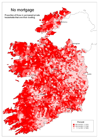
Dublin is shown to have the highest concentrations of households with mortgages, followed by the urban centres of Cork, Galway, and Sligo. “This is likely to be the result of young professionals locating to urban areas for employment,” says O’Connell.
The new series of GIS maps produced from 2006 Census data also show that the Gaeltacht areas have some of the highest percentage concentrations of mortgage free households in Ireland.
Other GIS maps produced in the series include:
- Ratio of single females to single males
- Dependent population
- Divorced persons
- Households with no motor car
- Households with two or more motor cars
- Use of public transport
- Daily time spent travelling
- Early risers
- Ratio of Irish to Non-Irish Nationals
- Irish speakers
- Voluntary activity
- Early school leavers
“This new atlas shows the power of making Census data widely available,” says O’Connell. “It encourages exploration of regional differences and suggests their causes. For example, the maps on commuting show that a large proportion of the working population spends much of the day commuting to/from work. Inevitably, this means less time spent in the community.”
All 36 GIS maps have been compiled and published in a book called: “A Sense of Ireland” which was officially launched by the Minister for Community, Rural and Gaeltacht Affairs, Mr Éamon Ó Cuív TD, in Dublin on 01 July 2008.
A Sense of Ireland
The Atlas contains information on selected themes which characterise a diverse and rapidly changing Ireland.
Overall some general issues emerged across all of the themes studied including:
- The rural-urban divide and, in particular, the clear distinction between East and West
- The influence of the greater Dublin area on the rest of the country. This is seen in maps such as those on House Mortgages
- Issues of sustainability also came to the fore as prominent headings which do merit further research. The social, economic, and environmental costs associated with Ireland’s current infrastructural conditions were illustrated through this study
- Community participation, levels of disability and availability of carers was another theme which produced some interesting patterns. This was the first year that such information was taken into the census and as such this research project generated unique maps indicating country wide levels of disability, and community participation and volunteerism in Ireland
More broadly still, the Atlas shows the power of making Census data widely available. It encourages exploration of regional differences and suggests their causes.