Work Plan (HOLOS-IE Project Period and Beyond)
The project aims to create a specialized systems-based modeling tool (HOLOS-IE) that is finely tuned to the unique conditions of Irish and thereby EU agriculture. This digital tool will integrate farm-level and beyond data, mapping, and software enhancements to support informed land use decisions, GHG emissions reduction, and offsetting efforts, policy development while aligning with national and global sustainability goals. The specific objects are:
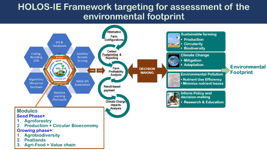
- Model Adaptation: Update and customize the Holos V.4 landscape model to create HOLOS-IE, specifically tailored for Irish agricultural conditions. This adaptation will align with the need for timely national scenario modeling to guide land use and management options and policy decisions in the context of climate change and adaptation, agri-environmental footprint, and food security.
- Dynamic Soil and Meteorological Mapping: Develop a dynamic combined soil and meteorological map for Ireland and the broader EU. This map will be integrated with the HOLOS-IE model, enhancing its precision and utility, and future projection. In the future, the use of Satellite or Remote Sensing approaches will be explored.
- Model Coding Enhancement: Modify, recode, and decode the existing model to accommodate changes in land use, management interventions, key drivers, and algorithms. This adaptation will ensure that the model accurately represents the evolving conditions in Irish agriculture and beyond.
- Software Platform Optimisation: Enhance and improve the existing software platform (HOLOS-IE) to cater to a wide range of users, including farmers, advisors, inventory staff, academics, researchers, and policymakers. This user-friendly interface(s) will facilitate easier access and utilization across stakeholders.
- GHG Emission and Carbon Sequestration Assessment: Evaluate the effectiveness and applicability of the modified systems model and software (HOLOS-IE) in simulating GHG budgets and carbon sequestration across various land uses including agroforestry and their combinations. This assessment will ensure the model's utility in addressing climate change mitigation and adaptation, agrobiodiversity and ecosystem services, value chain, and cost-benefit goals.
The project tasks are detailed as follows:
Development of Conceptual Framework and Architecture
This task will focus on developing a conceptual framework and land use-specific architecture for the updated landscape model, HOLOS-IE, tailored to Irish requirements. It will involve improving existing algorithms for compatibility with Holos V 4.0, with the goal of filling research gaps and enhancing national inventory reporting.
Collection, compilation, and synthesis of Databases and Algorithms
It will entail enhancing HOLOS V4.0 in collaboration with other projects, generating data, algorithms, and response functions. These will be adapted to Irish conditions (HOLOS-IE) in combination with EU databases by covering multiple land uses and management practices. This comprehensive approach will improve GHG estimation and environmental impact assessment and their mitigation.
Development of modules for integration into HOLOS-IE
This task will develop agroforestry and circular bioeconomy modules for seamless integration into the HOLOS-IE framework. The future goal is to create a unified platform that supports the development of modules focused on agrobiodiversity, peatlands restoration including agricultural farming, and the optimization of agro-food value chains, fostering synergies and innovations. This holistic approach will enhance the sustainability of agricultural systems while promoting ecosystem restoration and responsible resource management.
Dynamic Soil and Climate Mapping
It will integrate land cover, soil, and climate data into the HOLOS-IE model, incorporating a dynamic combined digital map that utilises Irish and European soil and meteorological maps to auto-fill basic inputs at a land parcel to farm level. This map will offer critical soil properties and weather data, including regional forecasting, enhancing the model's robustness.
Development of HOLOS-IE Digital Platform
This task will harness the capabilities of programming languages such as C#, machine learning, and Python in a multifaceted manner, leading to the development of the software HOLOS-IE. This platform will be strategically designed to center its functionality on the resolution of intricate challenges related to land use and management. Building on the above, this task will replace existing algorithms, EFs, and driving variables with newly generated ones. Coding, recoding, and decoding existing code within the model will be performed to accommodate Ireland and EU-specific land uses and management practices.
Development of Web-based User Interface and Testing
This task will develop a web-based user interface(s) with adaptability for diverse user categories, such as academics, stakeholders, farmers, and policymakers, to facilitate accessibility and usability. For this, rigorous testing to ensure functionality, user-friendliness, and effectiveness in meeting the unique needs of each user group, providing valuable insights and feedback for iterative improvements will be done.
Pre-assessment and Validation of HOLOS-IE
This will assess the suitability of the HOLOS-IE model for Irish conditions. It includes a pre-assessment of the environmental footprint across key land uses and management practices, analysing their benefits, limitations, and trade-offs. The model will be tested for its performance in quantifying GHG budgets, nutrient losses, and plant/livestock production with or without agroforestry. Sensitivity analysis will evaluate the model's response to climate extremes and alternative land use choices. While the project carries some risks related to data availability and validation, the team is prepared to address these challenges by developing proxies and using country-specific EFs.
Delivery of validated HOLOS-IE and Initiation of HOLOS-EU
This task will encompass the delivery of a comprehensive agricultural systems-based landscape model HOLOS-IE, with a focus on maintaining it as an open-source resource for public access. Concurrently, the initiation of HOLOS-EU will signify the expansion and customization of this innovative system to align with the unique requirements and environmental objectives of the European context, thereby promoting sustainable land use and industrial practices throughout the EU.
Follow us on