
In this blog about rescuing old river flow records, Kate de Smeth from the UCD School of Geography explains why and how hydrologists use historic documents to help understand river behaviour in the past, present and possible future.
“Is this normal?” and “Is it going to get worse?” are two of the most frequently asked questions of hydrologists working with policymakers to understand river-related risks to vulnerable communities. Whether we are researching extreme low flows (droughts) or extreme high flows (floods), it is critically important to understand whether catchment and river behaviour is changing over time, and what that might mean for the future.
To answer these questions, hydrologists look to the past to provide context for the river flows we see today. Hydrometric monitoring stations that record water level and flow information are one of our most valuable sources of historical river data. Yet accessing the oldest of these records isn’t straightforward and often involves diving deep into the dusty boxes of hydrometric archives. The painstaking process of salvaging historical data to make it publicly available is known as data rescue.
Across the island of Ireland, river and groundwater data is collected by several public and private sector bodies via the hydrometric monitoring network. The earliest monitoring began in 1939 by the Office of Public Works (OPW) for the design of the arterial drainage schemes. Data for many of these OPW stations are available online, but most of the oldest river flow data are stored as paper records in secure hydrometric archives in Headford, Co. Galway. In their current format, they are not easily accessible to researchers and so this limits our ability to examine river flows over time in these catchments.
 |
| Annual summary of daily water level readings for Station #26021 Ballymahon on the River Inny, Co. Longford,, October 1945 to September 1946. Source: Office of Public Works, accessed November 2021. |
Hydrometric data rescue has been completed for eight stations across Ireland to produce extended flow records back to 1939. The way that the data is rescued depends on its format, which itself depends on the hydrometric method used to collect the data. The image shown left is an example of the earliest data records in Ireland (1939-1950s) that contain a single daily reading of water level (and therefore flow). These were collected by local people employed by the OPW to read the water level off a staff gauge i.e. an upright ruler attached to the river bank or a bridge. These data need to be transcribed into a digital format and converted from an imperial measurement into the metric system we use today.
The image shown below shows the specialist equipment and software that is used to digitise weekly graphs of continuous water level data (1950s-2000s). These data were collected using an autographic recorder, which is a geared pulley system that connects a device floating on the river surface to a pencil that moves up and down on a rotating sheet of paper to track the rise and fall of the water level. Quality assurance checks are completed and then the rescued data is merged with any existing station data to produce extended records.
The collection of these historical river data will complement recent climatology data rescue projects by researchers at Maynooth University and NUI Galway who have worked alongside Met Éireann to extend Ireland’s temperature and precipitation records. These projects rescued decades worth of records by engaging secondary and/or university students in citizen science to preserve Ireland’s environmental history.
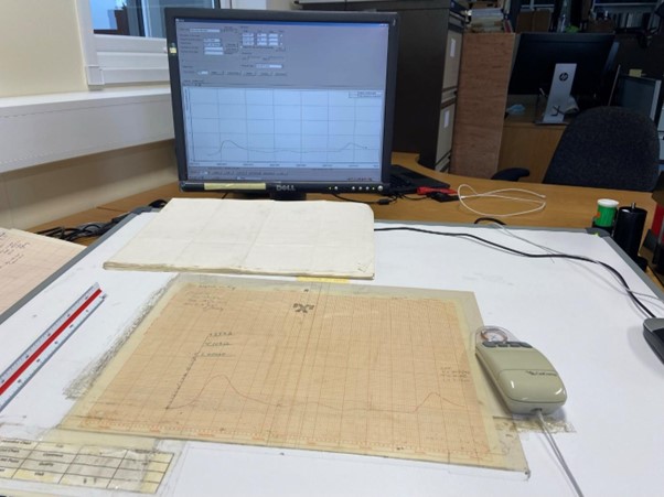 |
| Digitising equipment for continuous water level data at OPW Headford office. Photo credit: K.de Smeth, November 2021. |
Together these data rescue projects offer a window into past environmental conditions in Ireland, but importantly also provide empirical data to train hydrological models that are used to predict future river behaviour. Without these kinds of data rescue projects, the potentially valuable insights offered by historical data into the changing dynamics of Irish rivers will remain hidden. Hydrometric data rescue is therefore an important tool in a hydrologist’s toolbox.
Essay first published 23 November 2022.
About the author
Kate de Smeth is a PhD candidate at the UCD School of Geography and is funded by the Irish Research Council Enterprise Partnership Scheme in partnership with the Office of Public Works. Her research employs historical data rescue, time series analysis and hydrological modelling to contribute a baseline understanding of river behaviour in arterially drained catchments in Ireland for discussions around river management practices, climate change and flood risk management. Email: kate.desmeth@ucdconnect.ie
About the series
The A-Z of Environmental, Climate and Sustainability Research is a new series of short essays by UCD postdoctoral and postgraduate researchers, technical and research support staff, about their work. The series is developed and curated by the Earth Institute Associate Member Committee led by Hannah Gould, a PhD student at BiOrbic and the UCD School of Architecture, Planning and Environmental Policy, and Earth Institute Communications and Engagement Officer Liz Bruton. If you'd like to submit a piece for the series do get in touch!
Find out more about the Anthropocene with Nick Scroxton, Bees with Katherine Burns, Cannabis with Caroline Dowling, Degrowth with Ciarán O'Brien, Education with Georgina Fagan, Finance with Shane McGuinness, Gaia with Federico Cerrone, Hydrometry with Kate de Smeth, Innovation with Hannah Gould, Justice with Lauren Minion, Kelp with Priya Pollard, Landscape part 1 with Tomas Buitendijk, Landscape part 2 with Amy Strecker and Amanda Byer, Reusing microbial ‘bathwater’ for sustainable drug production with Laura Murphy, and Mammals with Virginia Morera-Pujol in our latest essays.
Further reading
Griffin, E.R. (2015) ‘When are Old Data New Data?’, GeoResJ, 6, pp. 92–97. Available at: https://doi.org/10.1016/j.grj.2015.02.004.
Mateus, C., Potito, A. and Curley, M. (2020) ‘Reconstruction of a long‐term historical daily maximum and minimum air temperature network dataset for Ireland (1831‐1968)’, Geoscience Data Journal, 7(2), pp. 102–115. doi: 10.1002/gdj3.92.
Ryan, C. et al. (2021) ‘Ireland’s pre-1940 daily rainfall records’, Geoscience Data Journal, 8(1), pp. 11–23. doi: 10.1002/gdj3.103.


