UCD Geoscience Itrax Facility


Welcome to the UCD Geoscience Itrax Facility. This Facility was originally established in 2008 using funding provided by the Higher Education Authority, and upgraded in 2021, generously supported by the (opens in a new window)Geological Survey of Ireland. It is run by the UCD School of Geography and UCD School of Earth Sciences. The Facility allows for interdisciplinary research based on elemental analysis of sediment, soil and rock samples. Further information on the facility and its equipment can be found below, along with contact information. We welcome any expressions of interest to use this Facility.
Why use Itrax?
XRF core scanning using Itrax has evolved to become a key rapid and robust analytical technique in a wide range of fields ranging from palaeoceanography, paleoclimatology, geology, and environmental forensics to environmental protection (Löwemark et al., 2019). The scanner offers state-of-the-art analytical precision and speed, with determination of chemical composition of entire core sections in a matter of hours. Itrax scanning offers a variety of benefits, including:
- Non-destructive, non-invasive, high-resolution, continuous element profiling for Al to U (Analysis for Mg, contact lab to discuss).
- Configuration for cores (sediment, soil and rock) up to c. 12 cm in diameter but can be adapted for slabbed samples.
- Coincident XRF element intensity (resolution to 200 µm up to 1 cm), X-ray radiography (resolution up to 20 µm), optical imagery (c. 50 µm) and magnetic susceptibility (4 mm).
- Scan times depending on scan resolution and count times; a 1 m core scanned at 500 µm and 5 s will take c. 3 hrs).
- Raw element counts that can be calibrated using geochemical reference materials and in-house geochemical standards.
- Magnetic susceptibility, using a point sensor, requiring contact with sample surface.
- Scope to merge with coincident geophysical and geotechnical measurements to better understand properties of Earth materials.
Facility Equipment and Support
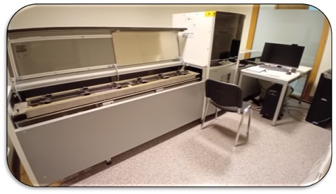
The UCD Geoscience Itrax Facility hosts a (opens in a new window)COX Analytical Systems X-ray Fluorescence (XRF) Scanner. This Facility has installed a RGB camera equipped with polarising and UV filters, a high-specification Type II XRF detector offering a maximum count rate of 300,000 cps, plus improved peak stability and peak-to-background ratios, and an improved vacuum sensor system. The facility also includes provision of an uninterruptible power supply (UPS) system to protect against outages during analysis.
The adjacent lab facilities also provide sample preparation space with core splitting and walk in cold room space for sample storage for the duration of analysis. The facility also hosts a (opens in a new window)Malvern Mastersizer 3000 for particle-size analysis.
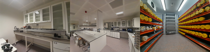
Figure 1 Core cutting, preparation and storage facilities at UCD.
Samples and Preparation
The preferred sample technique for analysis is split core, which needs to be flat and clean (e.g. Figure 1). However compressed pellets and other sample types can also be accommodated. Scanning of whole slim-hole core is possible but intensities may be reduced. It is preferable to avoid extensively fractured core, e.g. heavily disced fine-grained lithologies. Cores (25-100 mm wide) should be mounted in a half-pipe or U-channel in c. 1 m long lengths carefully labelled for depth and way-up. Most projects will involve metres to a couple of 10s of metres, and pre-screening areas of interest is vital to avoid redundant data. Samples successfully run on the Itrax XRF scanner include:
- minerogenic alluvium
- marl-rich lake sediment
- mineral and peaty soil
- speleothem
- complex ‘banded’ Calp
The suit of core scanner tools is applicable to a range of environmental applications:
- Palaeoclimate reconstruction in marine and lacustrine environments
- Constructing inter-core correlations and event stratigraphies
- Determining past erosion intensity
- High resolution analysis of laminated sediments, including varve counting
- Rapid detection of volcanic tephra layers in lake sediments
- Detecting metal pollutants (Pb, Zn, Cu) in lake and fluvial sediments
- Development of proxies for sediment physical properties such as particle size
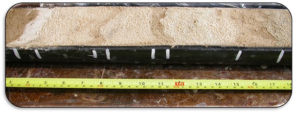
Figure 2 The micro-topography is determined through an initial surface scan. A flat, smooth sample surface allows for optimal positioning of the XRF detector during analysis.
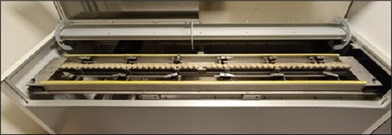
Figure 3 Compressed soil pellets mounted for calibration.
Further Information and Access
For information on analysis, rates and scheduling, please contact (opens in a new window)GeoscienceItraxLab@ucd.ie. Time on the Itrax scanner may also be funded through appropriate (opens in a new window)GSI funded research calls, when open.