Geophysics
The UCD Geophysics Group works closely with several of the other research groups with a focus on using geophysical methods to characterise the subsurface and to analyse geohazards. The main goals are to investigate the geophysical response of complex media, understand different geological settings and physical processes in the subsurface, predict the location of Earth resources, and support decision making using non-intrusive methods. The group applies existing geophysical techniques as well as developing new methods to help solve longstanding and emerging geological and geophysical challenges.
The main research areas are:
- Inversion and interpretation of multi-physics geophysical data using inverse theory and machine learning techniques for the purpose of geohazard assessment (e.g., inversion of volcanic sources) and identifying Earth subsurface resources (either through improved imaging or direct detection).
- Seismic wave propagation in complex media from observational, theoretical and modelling perspectives, and mainly applied to improved geohazard
Seismic wave propagation
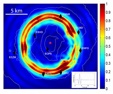
Scattering of seismic wavefield by volcano topography. Surface snapshot of long-period wavefield propagating across a homogeneous model of Mt Etna volcano, 4 s after the start of the disturbance. The wavefield is generated by a 600 m deep vertical force seismic source (red star). The colours denote normalised total magnitude of seismic displacement. Inset shows the source-time function used in the simulation.
In a model without topography, the wavefield would be represented by concentric circles. However it can be seen that the topography strongly affects wave propagation by focusing and defocusing seismic energy in a quite an unpredictable manner.
Inversion and interpretation of multi-physics geophysical data
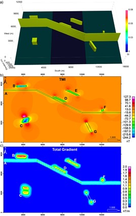
a) Synthetic model with similar dimensions to the Carajás Mineral Province (Brazil) containing a magnetic lineament (A), simulating the Carajás Fault, magnetic bodies B, D, E, and G simulating elongated mineral deposits with different orientations, F simulating a pipe deposit, and C simulating a magnetic intrusion. b) simulated total magnetic intensity data (TMI) at points spaced in a grid of 150 by 150 metres, 75 metres height, 23,500 nT magnetic field strength, −3 inclination, and −20 declination, and c) total gradient data computed from the TMI data showing the limitations on imaging the edges of body G ((opens in a new window)Melo et al. 2020)
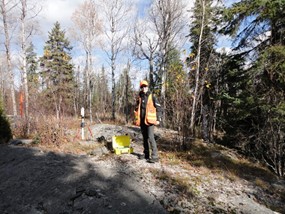
Dr. Melo taking measurements during a time-domain electromagnetic survey in Sudbury region, Canada
Find out more about the researchers and recent publications: