Quantification of Salt-related Sinkhole Development and Migration - 1 year fully-funded MSc research studentship
Supervisors: Dr. Eoghan P. Holohan School of Earth Sciences, UCD Dublin; Prof. Frank McDermott School of Earth Sciences, UCD Dublin
Collaborators: (opens in a new window)Prof Torsten Dahm German Research Centre for Geosciences (GFZ Potsdam), Germany; Dr. Ali Sawarieh, Ministry for Energy and Mineral resources, Jordan
Short summary: The Dead Sea region is the world’s foremost natural laboratory for observing the effects of salt-related land subsidence and sinkhole collapse. This project is an opportunity for you to take a step towards a career in natural hazards research by mapping and quantitatively analysing the development of such phenomena on the eastern coast of the Dead Sea, and testing hypotheses regarding the processes driving them. Funded by the Geological Survey of Ireland, this 1 year MSc research project will involve collaboration with scientists in Germany and Jordan. Funding includes a stipend plus payment of EU tuition fees. For more information on the project and how to apply please see here.
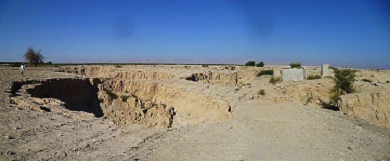
Figure: Sinkholes in alluvial fan deposits at Ghor Haditha, Jordan. Note the destroyed road and farm buildings, as well as the person for scale. Photo taken in October 2014 by E.P. Holohan.
Surface wave removal from seismic reflection data using seismic interferometry
PI: Dr Ivan Lokmer School of Earth Sciences, UCD, Dublin
Co-PI: Dr Gareth O'Brien, Applied Geophysics Group, Tullow Oil, Ireland
Project summary: While there are seismic techniques which make use of surface seismic waves in imaging the subsurface, there are also those where these types of waves are considered coherent noise. Important examples where the surface waves may significantly degrade the obtained images include different types of reflection seismic surveys (shallow surveys for engineering, environmental and groundwater investigations, and deep surveys for imaging hydrocarbon reservoirs). In a strongly heterogeneous medium, the conventional methods for attenuating these surface waves (such as f-k “velocity” filtering) often do not give satisfactory results. This project will investigate the best practices for the surface wave removal by using the advances in seismic interferometry. Specifically, the seismic signals from different receiver gathers will be cross-correlated in order to generate the surface wavefield between the receivers in question (generating virtual source-receiver pairs). After the surface-wave gathers are produced for the whole survey, they will be adaptively subtracted from the recorded raw data. The best practices for the isolation and adaptive subtraction of surface waves, as well as the general feasibility of the proposed method, will be investigated. This GSI-sponsored short project will employ a research assistant for 6-7 months. For more information on the project and how to apply please Surface wave removal from seismic reflection data using seismic interferometry - Application information.
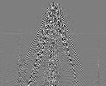
Figure: An example of cross-spread gather from a 3D seismic survey contaminated by "ground roll"
Developing a toolkit for model evaluation using speleothem isotope data
PI: Dr Laia Comas Bru School of Earth Sciences, UCD, Dublin
Co-PI: (opens in a new window)Prof. Sandy Harrison University of Reading, UK
Short summary: Reconstructing past climates is crucial for quantifying and understanding natural climate change, which in turn is essential for the validation of climate models that are used to provide future climate projections. This project is linked to the SISAL (Speleothem Isotopes Synthesis and Analyses) initiative sponsored by Past Global Changes ((opens in a new window)PAGES) which is aimed at creating a speleothem database that will significantly contribute to expand the geographical availability of palaeodata, thereby improving the reliability of the data-assimilation techniques used in model evaluation. This GSI-sponsored short project will employ a research assistant for 8 months to help with data collection and data entry as well as to contribute with data analyses and the everyday organisation and discussions of the Working Group.
.jpg)
Figure: Global distribution of speleothem isotope records identified by SISAL (n = 520). In some cases, the circles overlap because more than one record correspond to the same cave site.
Geological GHG Emission Mitigation (GEM) : A preliminary investigation of crushed basalt as a soil amendment to sequester atmospheric CO2
Supervisors: Prof. Frank McDermott School of Earth Sciences, UCD Dublin
Short summary: This project will evaluate the rates of basalt weathering as a function of soil type and land use to determine if natural silicate weathering rates can be accelerated to consume atmospheric CO2 on short timescales by adding crushed basalt to soils. Co-benefits of using basalt as a soil amendment include the partial avoidance of CO2 emission from Aglime, increased runoff alkalinity to buffer oceanic pH and enhanced availability of P and other critical plant nutrients. This project will investigate the optimal conditions for accelerated near-surface silicate rock weathering by adding crushed basalt in a range of field conditions in Ireland and by measuring the increase in soil-solution elemental fluxes of base cations, compared with adjacent controls.
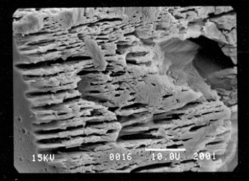
Figure: Etching of An-rich domains from a plagioclase feldspar grain that was buried in an organic-rich peaty soil for two years in SE Ireland. Scale bar is 10 microns