Assoc Professor Eoghan Holohan with Dr Simone Fiaschi awarded Irish Research Council funding
Irish Research Council EPS Postdoctoral project
Title
Karst-related subsidence in Ireland: geological and satellite-based detection schemes for planning and monitoring of infrastructure
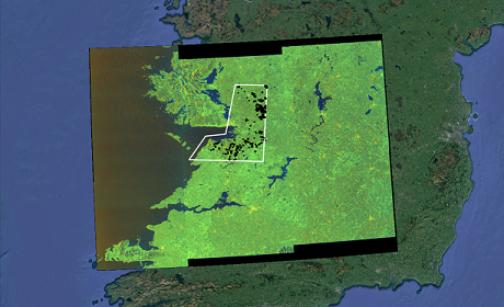
Figure caption
Satellite-based radar image of western Ireland acquired by ESA Sentinel-1A satellite. The white polygon outlines the study area of North Clare/East Galway and the Burren. The black dots represent karst-related depressions (sinkholes) in the area.
Summary
Dr Simone Fiaschi was awarded with an Irish Research Council EPS Postdoctoral fellowship in which he will use remote sensing and other techniques to understand the structural geological controls on cavities and subsidence in mantled karst regions of Ireland, and to monitor infrastructure potentially affected by karst processes.
Much of the world’s landscape, including Ireland’s, is underlain by or composed of water-soluble (‘karstic’) rocks, such as rock-salt, gypsum or limestone. In nature, the dissolution of these rocks by groundwater typically results in underground cavities or fissures, a process that can be influenced by human activity. The gradual subsidence or sudden collapse of the overlying rock or soil into such cavities or fissures can produce 1-500 m diameter depressions, termed ‘sinkholes’ or ‘dolines’, at the ground surface. The cavities and related instability associated with karst rocks can present significant engineering challenges for the development of infrastructure. In Ireland, these challenges have come into focus with the development of the national motorway network over the past two decades. Several karst-related issues encountered during construction of the M7/M8 in Laois/Tipperary/Cork and, more recently, of the M17/18 through the highly-karstified and ecologically-sensitive Gort Lowlands in Clare/East Galway.
The goals of this project are two-fold. Firstly, the elucidation of structural geological controls on cavities and subsidence in mantled karst regions, such as in lowland Ireland. This will involve the detailed mapping of karst and structural geological features in the Clare/East Galway study area. Secondly, the testing of a satellite-based monitoring approach for detection and monitoring of subsidence related to karst (or other) processes in Ireland, in particular with respect to new or planned infrastructure. The will involve use of the InSAR technique (Synthetic Aperture Radar Interferometry), whereby successively-acquired satellite images of an area can be compared to reveal mm-scale displacement of the Earth’s surface.