Improving resilience to the threat of coastal flooding
UCD CS is a partner in the (opens in a new window)UrbanARK project which aims to improve the resilience and emergency preparedness of urban centres and their communities to coastal flooding. Flooding is a growing threat because of climate change and so this project is timely.
Underground spaces a priority flood risk
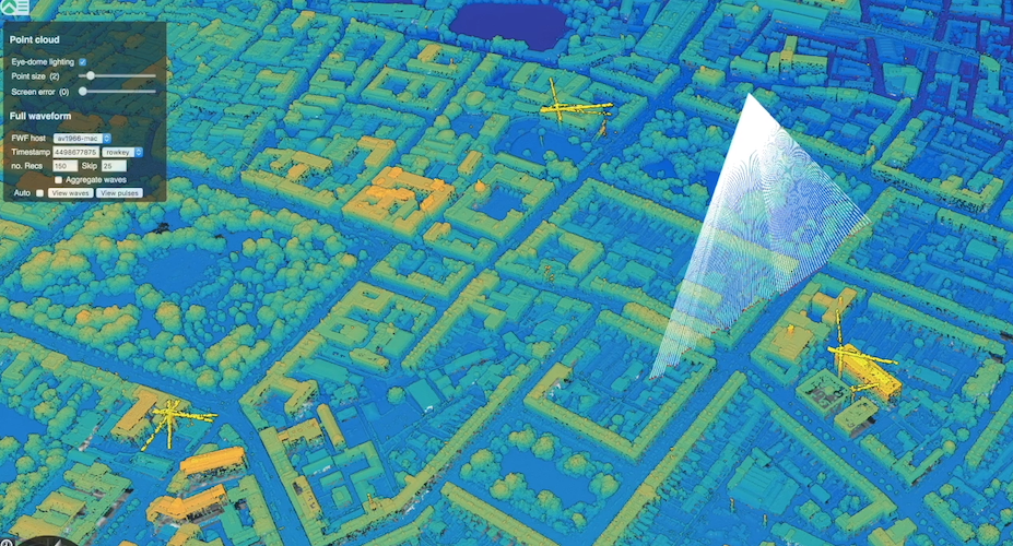
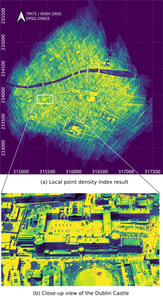
Within urban centres, underground spaces such as storage areas, transportation corridors, basement car parks, public facilities, retail & office and private spaces (such as residential basements) present a priority risk during flood events with respect to timely evacuation. However, often the location, geometry and volume of these underground spaces are not well known. Furthermore, these underground spaces are commonly not considered in urban flood prediction models.
Communicating risk to the public
At the same time, communicating flood risks and enhancing emergency preparedness poses further challenges. The use of these urban underground spaces is highly varied and the perception of risk differs from one user community to the next. Thus emergency planners need engaging communication tools to increase community resilience and preparedness to flooding events. One big impact outcome of the project is that the data collected is going to be made available to the public.
New technologies and more accurate models
The project harnesses new technology in the area of remote sensing, high-resolution street view imagery, distributed computing and visualisation, including the presence of underground spaces which are currently not taken into account by predictive models. With more accurate models, emergency planners can help protect people and property. The models will provide refined information on flood levels and flooding rates into the underground spaces, which in turn will be used as part of a newly developed risk communication tool comprising a low-cost virtual reality application. This tool will then be able to communicate the local flood risks to urban communities directly, providing an immersive experience of flood risk with the aim to better engage communities in emergency preparedness, thus increasing community flood resilience.
The benefits of international collaboration and shared expertise
For the UrbanARK project, UCD collaborated with New York University and Queen’s University Belfast. The project builds on the respective institutional strengths of each university, while fostering regular cross-fertilization and synergistic team building. In doing so, it interweaves the leading interdisciplinary research expertise of civil engineers, social scientists, geomaticians, and computer scientists. UCD contributed expertise in the area of spatial data management and looking at ways to help flood prediction and risk assessment for coastal urban communities. UCD’s team is led by Professor Michela Bertolotto as UCD Principal Investigator with Assoc. Prof, Nhien-An Le-Khac as co-PI.
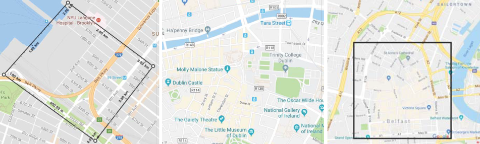
Three cities
Three cities (Dublin, Belfast and New York) were case studies and the team was able to incorporate the expertise and stakeholders in emergency management and planning in each city to learn from each other. The interchange, interaction and co-learning was an exciting aspect of the project. Each city poses unique challenges and has its own distinctive character. In combining the three study areas, the investigations covered the range of different underground structures typically encountered in coastal urban centres, including a broad mix of urban communities.
New York University’s Dr Debra Laefer comments that “international collaboration is important because it really brings the best knowledge, the most up-to-date thinking and the most expanded vision of research in this modern context… it gives the opportunity to participate in not only cutting edge research but being able to absorb and to experience perspectives from around the world.”
Dr Ulrich Ofterdinger at Queen’s University in Belfast is leading the QUB team. In their conversations with Belfast City Council on the risks posed from climate change to the urban environment and Belfast, one of the main concerns was the coastal flood risk in the city center. Dr Ofterdinger explains how “the research findings were developed between the different teams working together but then also in close collaboration with the stakeholders in the case study areas. The data that we collected - the scans of the case study areas allowed us to produce visualizations of the neighborhood environment that can then be used to show residents and people who live and work there what a flood risk actually looks like.”
For the researchers it is an opportunity to internationalise their research and through the partnership achieve great visibility.
![]()
UrbanARK - a showcase for international collaboration
(opens in a new window)Intertrade Ireland selected UrbanARK to showcase the success of the SFI US-Ireland R&D programme which links researchers across Ireland, Northern Ireland and the USA. The programme has funded 86 projects to the tune of €141 million to address global issues that require ground breaking thinking. Watch the video at (opens in a new window)US Ireland R&D Partnership | UrbanARK Project
The Project is jointly funded by the Northern Ireland Department for the Economy (USI 137),US National Science Foundation (NSF Award 1826134) and Science Foundation Ireland (SFI 17/US/3450)
Published 29th January 2024